Search
Items tagged with: maps
UPDATE 2: We're carefully back online again, with a few exceptions:
https://mapstodon.space/@lokjo/114657821935053517
Can we have a lill boost please? The fediverse is the only place we're on.
We're a replacement for googlemaps.
European, non-commercial, pro-local.
Thanks for sharing 😊
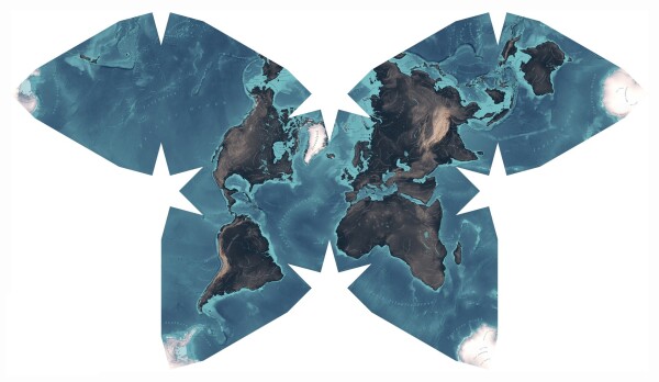
The wonderful Waterman Butterfly World Map that @fabian and I created a few years ago from scratch is now available for download!
As I wrote back in 2019: »I always wanted to design my own maps. But it seemed difficult and trivial at the same time. […] Then I discovered the Waterman Butterfly projection. And I was in love.«
If you want to find out more about our design process and the technical challenges (or if you just want to download the map) read on:
https://interface.fh-potsdam.de/butterfly
#maps
Shaping a butterfly
How we created a beautiful world map using open-source data & software. Download it to print your own!interface.fh-potsdam.de
My version shows a very profiles (horse riding!), and apparently a way to import a profile. Is there anything for hiking?
#OpenStreetMap #OSM #maps #wandern
Any #maps / #oldMaps fans out there? Institute of #History PAN has recently created a site showing georeferenced historical maps of #Poland (with somehow loose definition, as Poland tended to wander substantially during the time). Mostly 19th and 20th century, for now. Broad boundaries are years 1796-1947, scale from 1:25000 to 1:500000, and city plans. There are some vague informations about extending the collection, but nothing specific yet.
No English interface (or I haven't found a way to switch), but it's easy enough to use, I suppose.
 https://en.osm.town
Their official description: "An independent community of OpenStreetMap people on the Fediverse/Mastodon. Funding graciously provided by the OpenStreetMap Foundation."
You can find more map-themed servers at https://fedi.garden/tag/maps-and-geospatial
#FeaturedServer #Fediverse #OpenStreetMap #Mapping #Maps

En OSM Town | Mapstodon for OpenStreetMap
An independent, community of OpenStreetMap people on the Fediverse/Mastodon. Funding graciously provided by the OpenStreetMap Foundation.Mastodon hosted on en.osm.town


